


monastier-masclaux

danieljpn
User
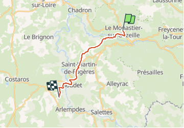

Length
14.6 km

Max alt
1007 m

Uphill gradient
508 m
Km-Effort
21 km

Min alt
763 m

Downhill gradient
471 m
Boucle
No
Creation date :
2021-08-23 05:45:30.754
Updated on :
2021-08-23 11:06:29.846
3h50
Difficulty : Difficult

FREE GPS app for hiking
 SityTrail
IGN / Geographical institutes
SityTrail Plus
The world is yours!
About
Trail Walking of 14.6 km to be discovered at Auvergne-Rhône-Alpes, Haute-Loire, Le Monastier-sur-Gazeille. This trail is proposed by danieljpn.
Positioning
Country:
France
Region :
Auvergne-Rhône-Alpes
Department/Province :
Haute-Loire
Municipality :
Le Monastier-sur-Gazeille
Location:
Unknown
Start:(Dec)
Start:(UTM)
578363 ; 4976865 (31T) N.
Comments